From Gangtok, it is a 6 hour drive along twisting mountain roads to Yuksom. Thankfully, our trek included a private car to drive us the whole way, with our guide riding shotgun. Though the road is not nearly as busy with traffic as the road between Siliguri and Gangtok, it is still an adventurous drive through the Himalayan foothill region. As the crow flies, the two are separated by less than 50 miles. However, in this terrain, the road winds down deep canyons, crosses rivers and then winds back up the other side and over a low pass, only to start all over again. With maximum possible speeds on the (often dirt) rough roads seldom reaching 30 miles and hour, the 150km ride (90 miles) seems eternal. Of course, there was plenty to keep our eyes occupied.
 |
| High-tech fire suppression system at the local diesel station. |
Touring monasteries in Sikkim, Nepal and Tibet is very popular. There are many companies which do special monastic tours - concentrating on visiting the various different types of monasteries from both a religious and architectural point of view. For me, this would be a bit like touring the churches of New England. The first few would be fascinating... then it would start to all look the same to me. I suppose if I were studying Buddhism, it might be different - but then, MANY things would be different...
 |
| Luckily, we arrived at the Bon Monastery just before a busload of tourists (we couldn't be considered tourists - we were trekkers hee hee). |
 |
| No matter what their meaning, you can't deny the beauty of their symbols and architecture. |
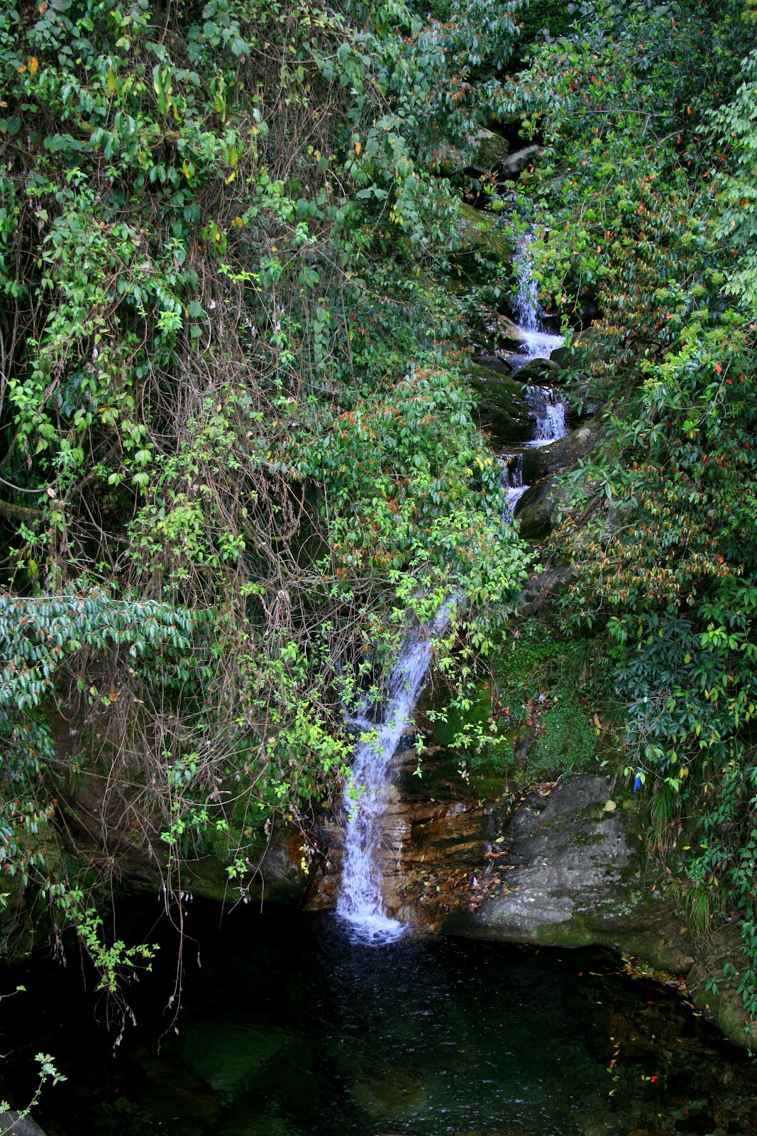
The final stop before Yuksom was at a roadside waterfall. Again, we had to ask to stop, and we were told not to take too long. Probably a good idea, since waterfalls can eat up a lot of time for folks like Sarah and I - but it was also a sign that our guide was in a hurry for some reason. Hmmmmmm....
 |
| Phamrong Falls. How could you call your self a photographer and not insist on stopping here! |
 |
| Yes, it says, come and visit...explore...see more... |
 |
| Worthy of more than a quicke - but, then, we had SO much more to see! |
 |
| I think the trees in bloom beside the falls are rhodedenderons |
Finally, we arrived in Yuksom. This small village is considered a model of ecotourism - at least in India - and it's location at the southern boundary of Kangchenjunga National Park makes it a real magnet for trekkers, climbers and other adventurers. The town also has a lot of historical significance, however. It was the first capitol of Sikkim, in 1642, when Phuntsog Namgyal was crowned the first Chogyal (temporal and religious king) of Sikkim (okay, so I stole this directly from Wikipedia).
We were a bit surprised by our hotel, especially when our guide took us straight up the stairs and picked out a room for us by checking to see which one was not being renovated at the moment. Amid the grinding and banging of tile work in the other rooms, we settled in (which meant unpacking and figuring out how the water turned on in the bathroom). Though we were both desperate for a hot shower, we decided to check out the town first, then shower before we met our guide again for dinner. He had some urgent business (evidently) - so we were on our own for a while.
 |
| View from our hotel across |
 |
| Stupa in the center of Yuksom |
 |
| Entry to the monastery |
 |
| The monastery was closed, but the outside was quite spectacular on its own! |
 |
| Road to Norbugang |
a |
| A dzo (yak-cattle hybrid) and prayer flags |
 |
| This young man was so happy with his bicycle... |
 |
| (photo by Sarah) - notice: no tires, no pedals, no seat - no problem! |
One of the important sites in Yuksom is the actual coronation throne used to create Sikkim back in 1641. They've made a historic park out of the site - which is a mix of history, religion and nature walk. It's a beautiful, eerie place to visit on a misty afternoon.
 |
| The trees within the park are painted and trimmed, and prayer flags are hung everywhere. |
 |
| We thought this was a big prayer wheel! |
 |
| But then we saw this one! It took a firm grasp and a quick walk to spin it, but you were rewarded for your effort with a bell that indicated that the prayer was going to heaven. |
 |
| The middle "seat"m (and remember, this is a floor-sitting society) was for the Great Nyingmapa Lama Lhatsun Chembo - the first king of Sikkim. The other three platforms were for the three lamas which met to crown the new king (Yusom is said to mean 'the meeting point of the three lamas'). |
 |
| Another street scene |
 |
| The pond - or "Katok Pokhri" is a holy lake. We came in around a back way, unaware that there was a gate where we should have paid a few rupees to see the site. Maybe next time... |
Yuksom was certainly not a bustling metropolis, but we did manage a little fun shopping and dining while we were there...
 |
| My awesome 'Made in Nepal' Yak wool mitten/gloves. How could I say no to these babies?! |
 |
| The Yuksom shopping district (the next morning) |
 |
| Sarah models her favorite find of the trip...a yellow plastic belt with a holographic dollars buckle. Yup. She's money. |
 |
| How can you have a bad day when your tea comes in cups like this? |
 |
| Tibetan breakfast: yak cheese, Tibetan bread and masala omelet with chili sauce. I had toast. |
Before we turned in for the night, we met with Raj (our guide), who gave us some packing tips and other instructions. He also let us know that he'd so far been unable to find a cook or a porter for the trip. Considering that meant we were going out with only the help of a guide, a yakman and 3 dzo's, I was not too worried. Raj, however, was plenty worried - he didn't want to have to serve as the cook, guide AND porter!
By the next morning, he still had not secured the help he needed. I was still coughing a good bit, and having trouble eating real food, so when he suggested a shorter day than the original plan of 10+ miles and 3000' elevation gain, I was totally on board. It was a part of his plan to solve the cook/porter problem - but we wouldn't really figure that out until later...
So, with only our daypacks on our back and a dream in our hearts, we departed Yuksom for the wilds of Kanchenjunga National Park.
 |
| First thing in the morning, the parade of pack-animals (or is that yak-animals?) begins... |
 |
| Our stuff, ready to get loaded onto our trusty 'steeds' |
 |
| Sarah and Raj follow our train of dzos along a path in Yuksom |
 |
| Village life |
 |
| Tashi, our dzo driver (yak man) and Larry, Moe and Curly. Don't get too attached - ladies and gentlemen, this cast changes throughout the series. |
 |
| (picture by Sarah) - our guide started out with the eggs...it was hard to believe they survived the whole trip like this! |
 |
| Hi-ho, hi-ho, it's on a trek we go... |
 |
| The official entry point to the park. |
 |
| As we got past the point where vehicles could go, the roads got much more primitive (and smaller, too!) |
 |
| Walkin' through the jungle |
 |
| Wild orchids along the trail |
 |
| The landslides were a result of the September 2011 earthquake. We were told not to stop through this section. Something tells me they're less than confident of their temporary trails... |
 |
| Some very LARGE trees... |
 |
| We crossed a number of foot bridges high above the creeks. I was rather proud of myself for not being at all freaked out by these slightly scary suspension spans! (okay, so I had too much fun with that one ;) |
 |
| The same bridge from above |
 |
| The jungle made for some very interesting trail time. |
 |
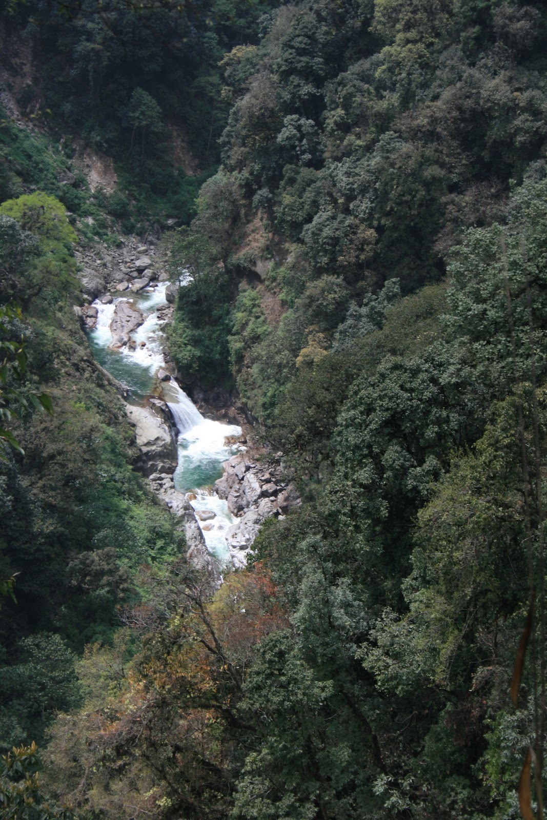
| A massive waterfall in the river a hundred or so feet below the trail. Would have been fun to check out, and we were hot enough that a dip was appealing. But the nasty trip down that hill would probably only be eclipsed by the trip back up... |
 |
| The dzo crossed the bridges with no problem...these are no finicky mules! |
 |
| This beautiful oasis looked like the perfect place for a swim, but our guide warned us that many people had died falling from the rocks just below the pool, so it was off limits. Too bad! |
 |
| (photo by Sarah) Crossing another bridge... |
 |
| (photo by Sarah) Finally, we arrived a Sachen. Not necessarily the sexiest of our campsites, but at least we had a place out of the impending rain! |
 |
| The yak-pen they call Sachen. Day's hike: 6km and 800meters gained (about 3.8mi, 2500 feet) |


Comments