Inspired by my good friend Sirena who has a most awesome blog of her adventures (including her completion of the Arizona Trail), and Bernie who kept an amazing blog on his long adventure through South America - I've decided to make a fresh start on the blog front. This renamed blog will combine both the Throwing a Wendy blog and the old Queen of Useless Knowledge, as well as give me a more appropriate place to share my trip photos, stories and observations on the world in general. Facebook is to face-less.
This Blog is all about me. So, if you think it's self-serving, vain and absurd - you're RIGHT! Might as well just sit back and enjoy it for what it is!
Most recently in my quest to see what's around the next corner...
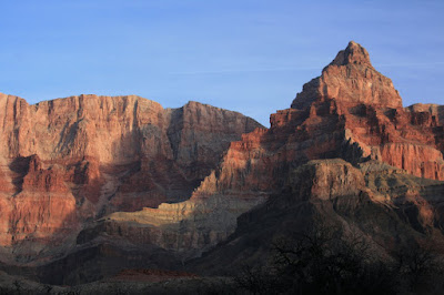
The Inner Canyon: Tanner to Grandview on the Tonto 2/2012
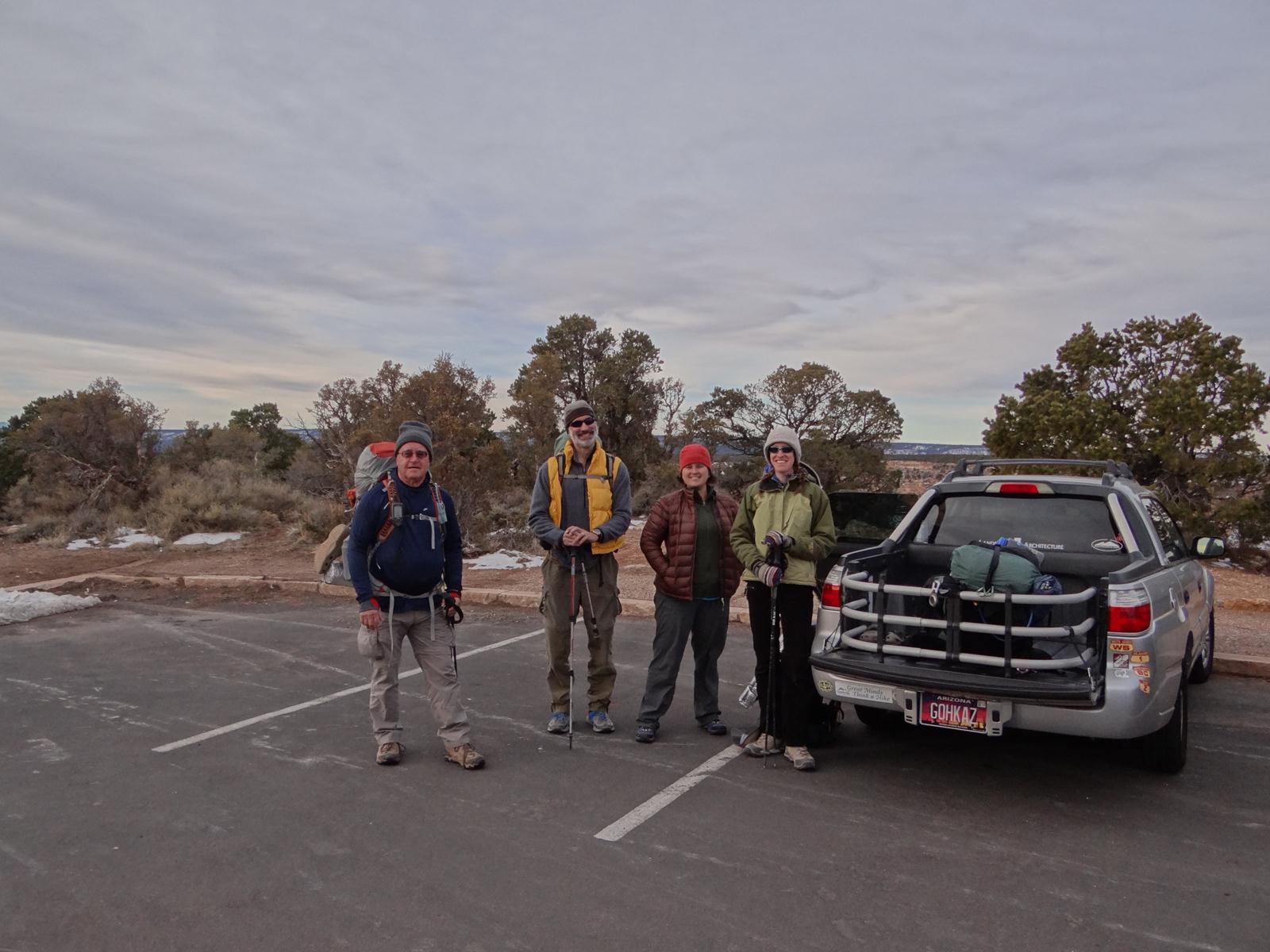
Clyde, Steve P., Sara S. and Wendy


This Blog is all about me. So, if you think it's self-serving, vain and absurd - you're RIGHT! Might as well just sit back and enjoy it for what it is!
Most recently in my quest to see what's around the next corner...
The Inner Canyon: Tanner to Grandview on the Tonto 2/2012
Clyde, Steve P., Sara S. and Wendy
This trip was originally supposed to be one of 3 I’d need to
complete the entire 125 mile long Tonto Trail below the Rim of the Grand
Canyon. I’ve already completed 14 miles
from Toltec Beach to the South Bass trail, 20 from Hermit to Bright Angel and
28 from Grand View to the South Kaibab for a whopping 62 miles of Tonto
action. This hike was going to add 41
miles of Tonto trail (and 54 miles total hiking) along the stretch called “The Gems”
between Hermit and South Bass. I’d spent
a bunch of time finding and arranging a commercial shuttle to take us out to
the South Bass Trailhead – which, because it is over 30 miles of dirt road
prone to muddy madness – we didn’t trust to be passable multiple times in a
month like February. Last time I’d been
to that trailhead in the spring, it had taken us over 3 ½ hours to drive that
30 miles back – and when I was done, my poor car looked like this:

No one wanted to deal with that kind of road over 3-4 trips
needed to set up a car shuttle for 5 people.
The commercial shuttle option, though pricy, was certainly a great
option. I’d get my Gems hike in, and no
one would need to risk a drop of mud on their tires. Perfect!
The canyon, though, doesn’t reward the complacent. The shuttle company waffled and whiffled,
changing dates and availability at the last minute. I rearranged the whole trip (including some a
volunteer project I had specially arranged to coincide with it) only to have
them once again try to reschedule. I realized
I just couldn’t trust them and called off their services. After hours of searching for an alternative,
we finally decided that we were just going to have to find another hike. Getting stuck in mud just isn’t the way to
start or end a big adventure. Of course,
all of this came about over the weekend and the President’s Day holiday, so we
had no idea what we would be able to do until we drove up on Tuesday
morning. This left us with a window of 6
days in the canyon and no clear idea of what we would actually be able to do
once we got there. I’ve never just shown
up at the BCO and said ‘what you got’, so this was going to be a first. Fun!
At the Backcountry Office, we discussed a few different
options for trip of that length that still made use of only highly accessible
trailheads. One of the options was a
different portion of the Tonto trail, further east and much easier to
access. It also meant a chance to add a
section of trail called the Escalante Route to my ‘done’ list – which would
bring the total of inner-canyon hiking miles to 134. Awesome!
So Escalante it is… we filled up on Mexican food in Tusayan and made our
new shuttle plans for the morning.
Day 1: Descend to greatness
After leaving Clyde’s truck at the Grandview trailhead, we
drove out to Lipan Point where we’d catch the Tanner. It was an unexpectedly long drive considering
that the hiking distance between the two trails was less than 40 miles. The sun was hiding behind a thin haze above,
which we hoped would burn off early.
The Tanner Trail turned out to be a delight. Though the top was somewhat icy as it
descended the initial switchbacks through the Kaibab and Coconino, it didn’t
feel as though it was dangerous at all, as it really is tucked into a nice
little drainage most of that way. We got
underway a little after 7:30am, and it was still quite cold, and the ice hadn’t
really gotten slick yet.
The views from
the higher points of the trail, down into the wide-expanse of the western
canyon and even across the plateau all the way to Navajo Mountain, were
fantastic. The massive wall of the
Palisades of the Desert was already looking intimidating, though nowhere near
as much so as it would from the river.
The view just screamed adventure and excitement and sore feet. Now THAT’s what we’re talking about!

Then the trail headed out onto a long, spiny ridge (Seventy-Five
Mile Saddle). This was certainly the
high point of this trail, at least figuratively. The steep walls of Tanner Canyon and
Seventy-Five Mile canyon drop off on either side into apparent oblivion, and a
spine of hodoo-like rocks called Stegosaurus Rocks along the top of the ridge
make for a fun alien-world scenario. We
kept thinking “this would be the MOST awesome camping spot”. Then we’d get down a little further and think
“no, THIS is the MOST awesome camping spot”.
It was good we weren’t planning on camping anywhere up there – the
options might have rendered us weak in the brain.

The trail contoured relatively gently along the base of a
couple of big buttes before dropping precipitously down through the Redwall –
always a fun section on Grand Canyon trails.
The steep downward grade just kept up until the trail reached the river
- not particularly hard hiking, but relentless, and torture for tired feet. At the beach, I kicked off the shoes and
rested with my feet in the air. We still
had at least a couple of miles to go – it wasn’t time to give in yet!
From the beach at Tanner, we hopped onto the Beamer trail
headed further East. The plan was for
some of us to dayhike out to the Little Colorado River confluence the next
day. The way my dogs were barking, I
knew it wasn’t going to be me. We made
it about 2 miles farther up before we called it quits on a lovely piece of
beach at the mouth of Comanche Creek. A few small mesquites and tammies that might
have provided shade if we’d needed it, and the nice quiet rapid was just enough
to sing me to sleep. The impassible wall
of the Palisades of the Desert was like a frame to an excellent little
sunset. The clouds finally retreated and
left us with an amazing star-studded sky, which in this wider portion of the
canyon made an amazing show.
Really, only 10 miles today?
How come my feet feel as though it were 20?

Day 2: Ravens delight
When the days are so short, I always feel a little guilty
about ‘sleeping in’ when I choose to not get up before the sun. However, considering the lower temperatures
and the shorter hiking days we had on this trip, there was no need for me to be
beating the sun. I cuddled in my orange
down haven perhaps a little longer than I should have, but it was pure bliss
after my fitful night of sleep the day before.
Steve and Sara left early for their own attempts at reaching
the Little Colorado. I hung around at
camp for a while, dealing with a leaky water container and my tired feet. Finally, Clyde and I hit the trail, hoping to
get at least as far as Palisades Creek (about 2 miles). We figured that was enough to give us a
stretch, but short enough to give our feet some time to recover.
The hike out to Palisades was easy and fun without a
pack. When we reached the creek, Clyde
turned around and I kept climbing, wanting to get an idea of how high above the
river the route would be further on. The
descriptions warned of precipitous 300’ drops – and I could certainly see those
coming. I stopped about a mile past
Palisades in a tiny drainage with a nice flat napping rock and great
views. I enjoyed a bit of goat cheese
and dates for lunch and watched the canyon’s glory go by.


The solitude of this part of the canyon in the winter is
staggering. I did see a boat trip
earlier in the day, but so far we’d seen no one else on the trails – even at
the top. Very few birds were about, and
even the lizards were scarce. I felt
entirely alone in the stony embrace of the canyon walls, and I felt very
safe. It was like my presence and
adoration were an acceptable offering to the canyon, who was herself feeling a
little lonely and ready for spring.
Upon returning to camp, I went to get myself a snack and
discovered that my food- which I had carefully tucked into a metal mesh ‘rat-sack’
- had been invaded. My best guess (and I
think it’s a good one) is ravens – as they’re active during the day and the
only creatures that I can see being strong enough to break through the metal
mesh of the bag. They ripped a 3” hole
in the sack and removed a startling amount of food. They completely consumed 5 medium tortillas,
4 complete home-made dehydrated dinners and a bag of Sports Beans. They even broke the foil on the salmon cup
and fished out every morsel in there. There were bits of plastic bags and dustings
of soup powder everywhere. They were so
untidy in their orgy that I couldn’t even begin to collect all the little bits
and pieces that were flung out in their joy.
I really hoped that the little food they’d left me would be
enough that I wouldn’t have to turn around and hike out early.

As Steve and Sara returned to camp, we took further
inventory of the group’s stores. It
seemed that I’d be able to make due with some creative meal planning and
perhaps a little calorie deficit. Even
as I tried to clean up, though, the ravens were returning to see if we’d left
them any more treats. Those blinking birds.
Steve reported that he’d made it to the LCR, though he’d
chosen not to descend all of the way down to the river level at the
confluence. Instead he enjoyed the view
and turned right back around. I was glad
I hadn’t tried to keep up – for Steve 8 hours of fast hiking would have meant
10-12 hours for me, and with as little food as I might have to live on the next
4 days, it was better for me to keep the exertion reasonable.
Another night under the gorgeous stars. Clyde shared his soup and tortillas with me,
and I made myself some hot coco. Life
certainly is good!

Day 3:
Straightforward, generally speaking
The next morning was a delightful day for hiking: sunny,
blue sky, a cool breeze to keep things light.
We made good time on the first few miles back to the Tanner Beach where
we’d pick up the Escalante Route. We
were just a short ways above Tanner when we saw a small metal boat heading
right for us. My first thought was that
they were NPS looking to check our permit.
Turned out that they were USGS and were servicing the cameras along the
river which are recording soil movement in the inner canyon. They were nice guys, and we talked for a
bit. When I asked if they had any extra
food, one guy reached into his lunch sack and gave me his hamburger and a
handful of chocolates. I wanted to tell
him I wasn’t desperate enough to steal someone’s lunch, but I wasn’t sure that
was the truth at that point. Instead, I
accepted graciously (I hope) and they headed off down the river. Their ‘barge’ was already half way to Phantom
– where they’d be sleeping tonight.
Between Tanner and Cardenas was indeed straightforward. The trail through the long, flat beach area was
well marked and easy to follow, though the sand did give us enough of a
challenge to make it interesting. On a
hot day, this stretch would be torture – without a stitch of shade and all that
white sand reflecting the sun back at you.
As it was, we were comfortable enough to take our time across the sands
and over the small hills to the floor of Cardenas Creek. From there it is just a short walk to the beach.


When we at Cardenas arrived, the pretty beach was deserted. We didn’t count out the fact that another
river group might come by, as we’d seen more on the water than we expected for
the time of year. We settled in for
lunch (1/2 a pound of cold ground beef on an English Muffin with no condiments…yum!)
and generally just enjoyed a long afternoon lounging on the sand.
Just before the sun began to set, we got company. The boat group was very friendly and willing
to work around us. They offered beer and
other treats (including a dark chocolate with chili – yum!) and were more
polite and well behaved than many of the private trips I’ve seen. They were on night 7 of 21…I was pretty
jealous. Then I saw them unloading tons
of stuff from their boats and felt a little better. I like the basic simplicity of backpacking –
all that stuff would make me feel overwhelmed.
I slept out under
the stars in the shelter of a mesquite’s branches. It was just like heaven – if only I’d had my
hammock ;)
Day 4: At the Unkar
Delta tonight: It’s the Supergroup, with special guests, Random Unnamed
Drainage!
The route out of Cardenas immediately begins climbing up and
over another Dox hill. It was a
recurring theme throughout the day. Up
and over an obstruction, back down to the river. Up, down, up down. If we’d been moving faster, we’d have been at
risk for seasickness.

Our goal was to camp along the Neville Rapids and save the
climb out of Pueblo Creek for the next morning.
It looked doable on the map, but once we got in sight of the massive
walls of the shoulders of Escalante Butte I started to doubt myself. It simply didn’t look like terrain you could
hike on, let alone follow a trail through.
The ragged spine of Tapeats atop the long ridgeline was a very
formidable boundary, and below it was an insanely steep slope of soft sandstone
and shale. I kept looking ahead and
saying ‘How on earth do we do this?’.

Turns out, you just go up.
And up. And up. We climbed all of the way to the base of the
Tapeats to a high saddle. This involved
a lot of sideslope walking that from even just a few yards away seemed
impossibly precarious. However, the
tread of the route was always reasonable when you were on it. It was amazing. The saddle is 800’ above the river according
to my GPS. Although it did feel good to
climb for a change, there was a bittersweet feeling to that victory as we knew
we’d be back at the river before very long.
As the trail began to descend into the arms of Escalante Creek, we were
faced with much of the same kind of hiking that had gotten us up there in the
first place, with some fun creek bed action thrown in at intervals to keep
things interesting.

At the small rapids at the mouth of Escalante Creek, we
watched a boat trip run through. One of
the members of the group was in an inflatable kayak, and he liked the action so
well he portaged back upstream and ran the whole thing a second time. It was fun to talk with him in his post-rapid
enthusiasm. Made me really want to try
some of those smaller, quieter whitewater sections in a ‘yak.
We weren’t on the river more than about 200 yards when we
began climbing. Again. This time we were ascending a sloping layer
of Shimuno sandstone into Seventy-Five Mile Creek. Yes, the same Seventy-Five Mile creek we’d
been at the top of at Stegosaurus Rocks days before. Only here, it’s a narrow slot. We made it to the back of the canyon, where
the creek cuts through the Shimuno to make a shelf. We paused for a break and pictures, then
began looking for the trail on the other side.
It seemed to be just a bunch of dead ends. Any
veteran of Tonto hiking knows that pattern, though – you hike up a little (or
down) until you get to a spot to cross the drainage, then you skip to the other
side and ‘Tontour’ out again. It just
wasn’t adding up here, though (which should have sunk in a little more since we
weren’t ON the Tonto). Finally, I dug
out the route description and was amazed that the trail actually was at the
base of the creek. Though the initial
drop into the creekbed seemed unlikely, it was actually quite easy. We lowered our packs, but in retrospect probably
did not need to. The rock is nice and
sticky, with lots of hand and foot holds and the slope is less severe than it
appears (I think because it is polished white).


I was quite tired when we reached the top of Seventy-Five
Mile’s slot canyon, but the descent and the fun canyon action below it revived
me considerably. I love walkable slot
canyons on any day, and surprise trips in walkable slot canyons are rare
indeed. Though I’ve been in narrower,
taller and more scenic slots, this one has a special place in my heart for
being such an unexpected delight.

Once at the mouth of the creek we continued hiking down canyon
until we found a beautiful, long stretch of beach along Neville Rapids. Unlike at Cardenas, we had the place all to
ourselves, and the sand was sugar sweet.
We took special pains to enjoy ourselves at our final river camp –
tomorrow we’d be up on the Tonto Plateau and the Colorado would be a distant
memory.
Day 5: Easier and
harder than you thought
When we started out for the fifth day, some of us were a bit
apprehensive. Though the route
description repeatedly reassured us that the scramble/climb out of Pueblo Creek
was ‘doable’, it was still an actual climb (rather than a scramble or hike) and
was often given as the one reason people didn’t even attempt this route. As someone who has struggled with acrophobia
my whole life, any time there’s a description of climbing, I get agitated. Not that I don’t press on – I’m just stubborn
enough for that – but I get a bit edgy.
We reached the mouth of Pueblo Creek very early. The hike between the beach at Neville and the
confluence was short and sweet, with some fun slab walking directly above the
water. It was very clear from the 20’
dryfall at the very base of Pueblo Creek that there was no getting around the
climbing on the far side. Clyde had been
nervous about it as well, and his solution was simply to tackle it straight on
and get it over with while the rest of the group was still taking pictures and
psyching up.

Once we saw how quickly and easily Clyde made the platform above
the falls, we all breathed a bit easier.
Okay, I breathed a bit easier. It
looked so much less challenging and scary than my mind had anticipated. I was
concerned about my camera, which was hanging loose for the whole hike. I turned my fleece vest around and zipped it
behind me, trapping the camera in a protective wrap against my tummy. I called it my ‘camera baby’, and found that
it was a surprisingly effective method of climbing with the big boy. Easily enough, we climbed and scrambled up
to the top of the cliff and enjoyed the downriver views for the 50 or so yards before
we caught sight of our next challenge.

The hike description I had says that a "talus filled runnel” allows passage back to the river, and
that it’s “steep, with lots of big boulders in precarious balance”. What it fails to mention is that the “Pueblo
Slide” is out-of-your-mind scary, and damn near vertical. As
recommended in the guide, we went down one at a time, waiting until the first
man had cleared the path of any falling rocks before the next proceeded. I hate
steep descents on loose rock under the best circumstances, and this was
definitely not that. Though it wasn’t
terribly exposed, a small slip would mean a long, uncomfortable and potentially
fatal fall. I dug my poles in, hung on
for my life, and s l o w l y descended the slope of the rockfall.

In what seemed to be an impossible feat of stubbornness over logic, stubbornness
won. Again.
Honestly, if I never have to do that
again, it’ll be years too soon.
But, like so many other miserable bits
of hiking – it was over soon and I was happily waiting on a nice, flat piece of
dirt about 30’ above the river while Steve and Sara took their turns coming
down (I might add that they were substantially faster than me, and that I was glad
to not have such a long wait as they had).
From there, it was a cakewalk to Hance Rapids and we knew that the very worst of what we could expect from this
hike was behind us. We knew it – but
then, we’d been wrong before.
While we were hiking across the river
level, we spotted the boat trip that we’d spent the night with at Cardenas
coming toward Hance Rapids. They all
pulled off on the north side of the river and climbed up to a low bench where
they could scout the rapids. I’m no
river person, but even I could tell that Hance is a BIG piece of water. We waited on the large rocks near the shore
while they debated (it felt like FOREVER), and then finally – one at a time –
put in down the rapids. One of the more
energetic boaters was running up and down the trail between the top and bottom
of the rapids, I assume giving advice as each boat came through. It was fun to watch and a nice way to spend
the late-morning (sitting on a rock watching other people work).

Finally, with the boaters back on
their journey downriver, it was time for us to hit the Tonto. Given that this was supposed to be an
all-Tonto-all-the-time kind of hike to start with, it sure took us enough time
to get there! The first mile or so of
the Tonto Trail as it left Hance was amazingly like the Escalante Route: same
color, same texture, same mixture of beach walking and side-slope
climbing. I was beginning to wonder if
I’d ever get to see the chalky beige dirt that is indicative of the Tonto I
know and love.
As the trail climbs up, the walls of
the canyon begin to close in and the familiar igneous ‘Granite Gorge’ begins to
appear. It’s quite interesting to watch
the Great Unconformity appear in this area as the Supergroup pinches into
nothing and the Tapeats becomes more massive.
Enjoying the geology is a great way to keep your mind off the steady
incline. We could see the tunnel
openings and tailings from Hance Mine across the river, too.

The trail here was still looking very
much like the Escalante Route doing an imitation of the Tonto Trail as we
climbed out of Mineral Canyon. Then we began into an unnamed
canyon which was pinching off the last of those deep red layers. At the back of this little drainage, like
magic, the Supergroup disappeared almost entirely and the dusty, chalky Tonto
Trail appeared. I’m not sure many people
would have understood my little dance of elation, but for me it was a
victory. I love this trail, so it was
quite the reunion! Although there would still be climbing and
rockfall dodging, it seemed like the unknown and unexpected would be over.
As we got deeper into the drainage,
it was clear that there was still a considerable amount of snow on the north
facing ledges of the South Rim. It was
such a surprise considering how hot we’d been much of the hike. As we continued around Ayer’s Point for over
an hour before we saw the worn maze of trails that was the camp and Hance Creek
below us. I spotted a hiker in the
campsite, and mistakenly thinking it was Steve, whooped and hollered in
celebration. It wasn’t Steve, and I’m
sure I looked like a fool – but considering that they were only the second
group of hikers we’d seen in 5 days, I suppose I had a good excuse.

The pair turned out to be a couple of
young people who worked for an outfitter in Flag and lead regular hikes with
tourists down in the Canyon. This trip
was just for them, though, and she’d been hiking in canyon for 28 (!) days, and
he for 14. They were on their last
couple of days, resting up and trying to eat their extra stores of food. They gave me a generous Mountain House
breakfast to round out my light food pack.
We swapped a few stories then went down the creek a little to camp under
the giant cottonwood and give the couple the privacy they deserved.
Hance Creek had a pleasant flow, and
our evening was a delightful one. The
winds had picked up most of the day, and with some high clouds blowing over
right at sunset there was some concern that weather might blow in
overnight. I put the rainfly on my tent
for the first time on the trip, so of course there was not rain at all and the
sky was full of bright stars. I think,
though, that the 4 nights I did have that view were better, since this time we
were deep in a narrow canyon with only a sliver of sky available to us. I certainly didn’t lose any sleep over it!

Day 6: The unexpected luge
Definition: A luge is an object that is designed
to be used for racing downhill over snow or ice - English Collins Dictionary
Hiking the next morning, we came to the
junction with the Miner’s Trail up to Page Spring came faster than we were
expecting. We’d left camp just a little after 8am, and by 9:45 we were up on
the mesa. Steve had never visited the
Horseshoe Mesa before, so he had lots of fun checking out the old mines on the
way up and the relics and ruins on the mesa top. The hike up to that point was as steep as I
remembered, though with most all of the food and water out of my pack, it did
seem like things were finally getting a little easier.
At first the climb was easy, as it
was in an area that got lots of sunshine.
However, the trail soon traveled onto the east-facing slope of the
break, and we began to encounter long stretches of slick, packed ice.

Steve, Sara and Clyde were a good bit ahead
of me, but I think the ice slowed us all down.
I put on my traction, which helped a lot, but certainly didn’t prevent
slipping and some feelings of dangerous instability. Sara, unfortunately, had only the instep
cleats – which are not only much less effective on hard ice than most other
devices, but also make walking across areas without ice nearly impossible. She ended up having to stop repeatedly to
apply and remove the cleats as we hiked up, which was not only time consuming
but obviously frustrating. In some
places, the ice was as hard and slick as a luge track, and we found ourselves
occasionally demonstrating poor luge technique with our poles and
backpacks. I was glad to be going up
rather than down this slick little nightmare.

It was almost 1:30 by the time we hit
the top of the rim. Not surprisingly
given the icy conditions, we’d only encountered a couple of day hikers on the
final stretch out. However the Grandview
Point was quite busy, and there were many ooh’s and aaah’s about how amazing
Sara and I were for hiking down in there.
One particularly funny and impressed older gentleman was going on about
how the miner’s got in and out of there.
When I explained to him the route and how I’d hiked in there the last 6
days, his response was simply ‘Are you crazy?’.
Well, clearly, I am. But I hope I don’t get cured from this crazy!
Clyde and Steve chivalrously drove
the truck right up to us and loaded us in.
After picking up the shuttle car, it was a quick drive straight to We Cook
Pizza for some serious post-hike pig out time.
Their salad bar is one of the best things I can imagine after 6 days of
dried, packaged food scavenged from ravens.
We languished over the pizza and already began inflating our
accomplishments into the stuff of legend.
While the rest of the crew headed
back for their homes, I went to check in to my lodging for the volunteer
project. I got to stay at the Albright
Training Center, which are delightful rooms complete with little kitchenettes
and huge soft beds. I ran to the General
Store and bought myself some beer and a pint of Ben and Jerry’s (which I’d
promised myself two days before), and sat down for the next 5 hours to read,
review maps, check email and pig out on Banana Split. I fell asleep with the light on and awoke at
6am to find over a foot of snow had fallen in the night.
Talk about timing!

The canyon giveth, and the canyon
taketh away. But on this trip, I think I
came out an big winner!
If you are a hiker and would like an even more detailed account of this hike, visit my trip report at hikearizona.com.
If you are a hiker and would like an even more detailed account of this hike, visit my trip report at hikearizona.com.
Comments